01 OVERViEW

Intelligent Ground Vehicle
-
Aimed to build a robotic vehicle with autonomous control that runs within the lanes, detecting and avoiding obstacles, navigating to reach a target/goal position in a semi-rugged terrain
-
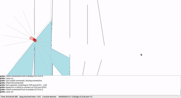
Adapted Vector-Field Histogram (VFH) algorithm for path planning and simulated it in ARIA's
MobileSim with a custom generated map of the environment -
Integrated data obtained from LiDAR scans, odometry from encoders and IMU to generate a map of the environment and localize the robot using SLAM methods in ROS (Robot Operating System), tuning and customizing the sensor network for three different iterations of mechanical design

02 MY CONTRiBUTION
We, a set of four girls, proposed a project for the Summer of first year of undergraduate studies and we became the founding team of Intelligent Ground Vehicle (IGV) project, where we aimed to develop an autonomous mobile robot for representing IIT Madras from India to compete in an annual International Competition hosted by Oakland University, Michigan, USA.

Initially, I worked on various aspects of project:
Obstacle Detection and Avoidance:
This involved learning and implementation of various sensors for ranging and mapping the environment such as IR sensors, ultrasonic sensors and LiDAR.
Simultaneous Localization and Mapping:
In this phase, the data collected through multiple sensors was fused into a comprehensive map of the surrounding environment of the robot, through SLAM-based algorithms.
Path Planning and Navigation:
Further over the dynamic map being generated, path planning algorithms such as Vector-Field Histogram, A*, etc. were simulated as well as implemented on the robot on the real scene created.
Integration of all Modules, Testing and Validation:
The robot was tested for autonomous navigation to the goal point using GPS inputs received, staying within the lanes and avoiding obstacles.
Shifting the Software Platform to ROS:
We used Navigation Stack package of ROS for the configuration of physical dimensions of robot and the positions of each of the sensors with calibration of their respective coordinate systems. Accordingly, a data flow architecture from the multiple sensors was developed for further processing.
Then, we used SLAM (Simultaneous Localization and Mapping) in the gmapping package to create a dynamic map of the obstacles / the environment and further by using AMLC (Adaptive Monte Carlo Localization), the pose of the robot was traced in the map.
After the localization of the robot, according to its position and orientation with respect to the target, the robot was given velocity commands to reach the goal by avoiding the obstacles in the shortest path possible. We programmed all of this in Linux platform and installed an edge-computing Nvidia Tegra unit for the processing.

03 ACHiEVEMENTS
The following year I took the additional responsibility of being the team lead, handling all the technological and financial aspects of the project as well.
A key objective of my leadership was to develop a string team that could sustain the developmental pace and make continuous improvements. I feel proud to say that the 14-member team that I helped create went on to secure top-3 positions out of a few hundred applicants worldwide.

Obstacle Detection and Avoidance
Configured a LiDAR to scan and map the obstacles on 2D plane, which was then integrated with lanes detected by the camera

Localization and Mapping
Fusion of data from multiple sensors to know the current heading and orientation of the vehicle or mobile robot
Path Planning and Navigation
The map is fed into the Navigation package to generate velocity commands for the robot's movement towards goal
The following year I took the additional responsibility of being the team lead, handling all the technological and financial aspects of the project as well.
A key objective of my leadership was to develop a string team that could sustain the developmental pace and make continuous improvements. I feel proud to say that the 14-member team that I helped create went on to secure top-3 positions out of a few hundred applicants worldwide.

04 LEARNiNGS

SENSOR CONFIGURATION
Calibrated and configured multiple sensors - LiDAR, Camera, IMU, GPS and rotary encoders for data fusion and processing

SLAM-based NAVIGATION
Implemented a network of sensors for mapping of environment and path planning algorithms for navigation

PROGRAMMING
& SIMULATIONS
The data collected was processed in ROS using NavStack package and it was configured, simulated and tested for the vehicle

Spearheaded the entire project and led a team of fourteen to achieve all the modules of the project as planned